Un ejemplo práctico
Supongamos que nos interesa un mapa turístico de una página web. La mayoría están elaborados con Google Maps API, pero no se nos facilita ningún mecanismo para exportarlos a nuestra cuenta y verlos en Google Maps o Google Earth. Sin embargo, sí que podemos examinar el código fuente y buscar las coordenadas:
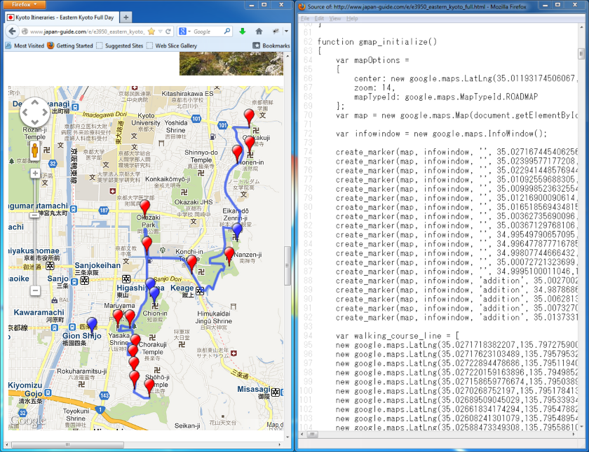
En el mapa aparecen globos indicando los lugares principales en rojo, y los secundarios en azul. En este mismo color, un camino que los recorre. Pues bien, copiamos las coordenadas y escribimos unas instrucciones tal que así:
putAttraction (
    (
        "Ginkakuji"
        "45 minutes - Ginkaku-ji (銀閣寺, Silver Pavilion) is a Zen temple..."
        (35.027167445406256,135.7973027229309)
    )
    ("Honenin" (35.02399577177208,135.79739391803741))
    (
        "Along the Philosopher's Path"
        "90 minutes - The Philosopher's Path (哲学の道, Tetsugaku no michi) starts just outside the approach to Ginkakuji..."
        (35.022941448576944,135.79561293125153)
    )

)

putAddition (
    (
        "Gion"
        "Gion (祇園). Check out the historical Gion entertainment district..."
        (35.00270020093859,135.77486336231232)
    )
    (
        "Sanjusangendo"
        "Sanjusangendo (三十三間堂, Sanjūsangendō) is an interesting temple that houses 1001 statues of the Buddhist goddess..."
        (34.987868671665495,135.77174127101898)
    )
)

drawPath (
    "Eastern Kyoto Full Day"
    "The following is a suggested full day itinerary for medium paced travelers that leads..."
    (35.0271718382207,135.79727590084076)
    (35.02717623103489,135.79579532146454)
    (35.02722894478686,135.79511940479279)
    (35.027220159163896,135.79498529434204)
)
He omitido muchos lugares para que no interrumpan la lectura de este texto. Los lugares más interesantes se crean mediante la instrucción putAttraction, y los secundarios con putAddition. La última, drawPath, dibuja el camino.
Guardamos lo anterior como input-instructions.txt, y ejecutamos pymappu:
D:\>pymappu-windows -i input-instructions.txt -ienc utf-8 -o mymap lat_lon
--path_ends_placemark_merge

Warning: --path_ends_placemark_merge is present but --merge_limit is absent.
Assigning default value of 10.000000 meters.
Expr rule correctly parsed
En entornos Unix utilizaríamos pymappu-unix en lugar de pymappu-windows.
Se genera una salida KML (en el ejemplo, el fichero mymap.kml):
<Placemark>
  <name>Ginkakuji</name>
  <description>45 minutes - Ginkaku-ji (銀閣寺, Silver Pavilion) is a Zen temple...</description>
  <styleUrl>#pathStartStyle</styleUrl>
  <Point>
    <coordinates>135.797275901,35.0271718382,0</coordinates>
  </Point>
</Placemark>
<Placemark>
  <name>Honenin</name>
  <styleUrl>#attractionStyle</styleUrl>
  <Point>
    <coordinates>135.797393918,35.0239957718,0</coordinates>
  </Point>
</Placemark>
<Placemark>
  <name>Along the Philosopher's Path</name>
  <description>90 minutes - The Philosopher's Path (哲学の道, Tetsugaku no michi) starts just outside the approach to Ginkakuji...</description>
  <styleUrl>#attractionStyle</styleUrl>
  <Point>
    <coordinates>135.795612931,35.0229414486,0</coordinates>
  </Point>
</Placemark>

<Placemark>
  <name>Gion</name>
  <description>Gion (祇園). Check out the historical Gion entertainment district...</description>
  <styleUrl>#additionStyle</styleUrl>
  <Point>
    <coordinates>135.774863362,35.0027002009,0</coordinates>
  </Point>
</Placemark>
<Placemark>
  <name>Sanjusangendo</name>
  <description>Sanjusangendo (三十三間堂, Sanjūsangendō) is an interesting temple that houses 1001 statues of the Buddhist goddess...</description>
  <styleUrl>#additionStyle</styleUrl>
  <Point>
    <coordinates>135.771741271,34.9878686717,0</coordinates>
  </Point>
</Placemark>

<Placemark>
  <name>Eastern Kyoto Full Day</name>
  <description>The following is a suggested full day itinerary for medium paced travelers that leads...</description>
  <styleUrl>#pathStyle</styleUrl>
  <LineString>
    <coordinates>
      135.797275901,35.0271718382,0
      135.795795321,35.027176231,0
      135.795119405,35.0272289448,0
      135.794985294,35.0272201592,0
    </coordinates>
  </LineString>
</Placemark>
Importamos este fichero KML desde Google Maps (o Earth), y el resultado es el siguiente:
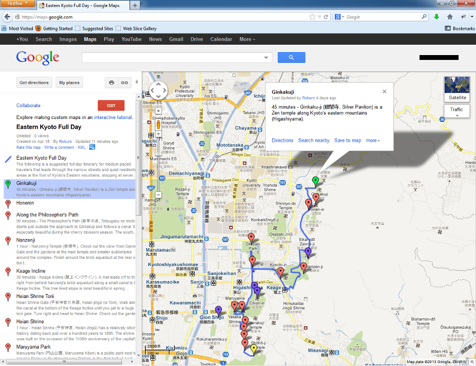
Tenemos el mismo mapa de la página web, importado en nuestra cuenta. Esto es ventajoso:
- La ventana es más grande, y por tanto, más cómoda.
- Modificaciones: cambio de colores y posiciones, adición de otros puntos..
- Uso como guía turística y orientación en un móvil Android / iOS con GPS. Probablemente lo más interesante.